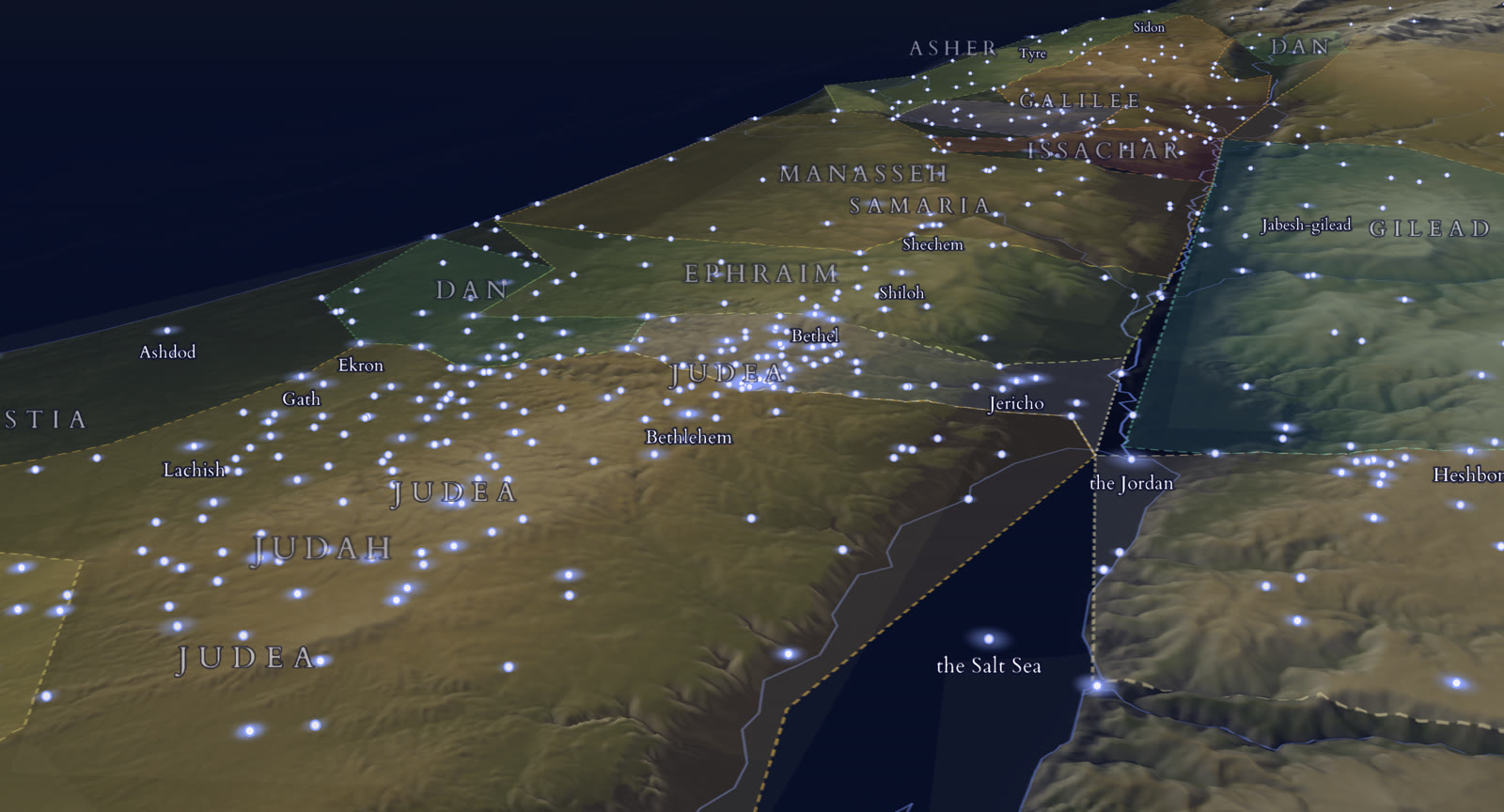
See the land of the Bible the way its first readers walked it. Tilt the hill country of Judah, follow the Jordan down to the Salt Sea, and tap any of 1,278 places to read every verse that names it.
Runs in any browser, on a phone, tablet or computer. No install, no account needed to explore.
The Seed Scroll Atlas: the tribal territories from Asher to Judah, with Jericho, the Jordan and the Salt Sea. Terrain: Mapzen Terrain Tiles, SRTM and Copernicus DEM. Places: OpenBible.info, CC BY 4.0. Water: Ancient World Mapping Center, ODbL.
What you can explore
The land of the Bible, in relief
Most Bible maps are flat. The geography of Scripture is not. Jerusalem sits on a ridge, Jericho lies far below sea level in the Jordan valley, and the road between them climbs about a kilometre. The Atlas draws the real terrain in 3D so the distances and the climbs in the text become something you can see.
1,278 biblical places
Towns, wells, mountains, rivers and regions named in Scripture. Tap Bethlehem, Shiloh or Hebron and every verse that names it opens beside the map.
The twelve tribes
The tribal territories from Dan to Simeon, with Manasseh on both sides of the Jordan, and the neighbouring lands of Philistia, Ammon, Moab and Edom.
Seven eras
Filter the map to the Patriarchs, the Exodus and Conquest, the Judges, the Kingdom, the Exile and Return, the Gospels, or Acts, and see the places that matter in each.
Real terrain in 3D
Tilt and turn the land to see the Judean hills, the Jordan rift and the Dead Sea basin as they are, not as lines on a page.
Place names two ways
Switch between the familiar English names and the spellings used in the Cepher, so the map reads the way your Bible does.
Ancient waters and regions
Rivers and seas from ancient-world mapping data, and regions from Galilee, Samaria and Judea to Bashan, the Negeb, Egypt, Assyria and Babylonia.
See it move
A 27-second tour of the Atlas
The land in relief, a tap on a place to open its verses, a narrated journey from Egypt to the edge of the wilderness, and a question asked of the map itself.
Everything in the video is the real Atlas, recorded in a browser at phone size.
Follow Abraham's journey, the Exodus, Jesus' last week and Paul's first journey stop by stop. Each stop is narrated, shows the distance travelled, and links the verses for that leg of the road.
Ask the Atlas Premium
Type a question like "Where did Moses see the promised land?" and the Atlas answers with the place and the verses behind it.
From the map to your study Premium
Turn a journey stop into a reading plan or an AI-assisted study, and keep studying in the same app you read in.
In the Atlas
Free
Premium
3D terrain, tribes, regions and waters
Yes
Yes
1,278 places with the verses that name them
Yes
Yes
Era filters and the place-name switch
Yes
Yes
Narrated journeys
–
Yes
Ask the Atlas a question
–
Yes
Premium also unlocks Hebrew and Greek letter study, Semantic Insight, AI Bible search, community study notes and AI reading plans across Seed Scroll.
Why it helps
Why a map changes how you read
Place names carry a lot of the story in the Bible, and most readers pass over them. When you know that Bethel sits on the ridge road north of Jerusalem, that Shiloh is tucked into the hills of Ephraim, and that the Jordan valley drops below sea level on its way to the Salt Sea, the narratives start to have distance, direction and weight.
Reading the patriarchs: follow Abraham from Shechem to Bethel to Hebron and see why the hill-country route mattered.
Reading Joshua and Judges: see the tribal allotments on the land itself, and which tribes held the hills and which the coast.
Reading the Gospels: trace the road from Galilee down the Jordan to Jericho and up to Jerusalem.
Reading Acts: follow Paul's first journey out from the land to the wider world.
Questions
About the map of ancient Israel
Is the map of ancient Israel free?
Yes. Exploring the 3D map is free in any browser at app.seedscroll.app/atlas: the terrain, all 1,278 places and the verses that name them, the tribal territories, the eras, and the place-name switch. The narrated journeys and asking the Atlas guide a question are part of Seed Scroll Premium.
Is this a map of modern Israel?
No. It is a map of the land as the Bible describes it: the territories of the twelve tribes, regions such as Galilee, Samaria, Judea, Gilead and Moab, and the towns, wells, mountains and waters named in Scripture. Modern borders and cities are not drawn.
Where do the places and the terrain come from?
Place locations come from OpenBible.info (CC BY 4.0). Terrain is built from Mapzen terrain tiles, SRTM and Copernicus elevation data, and ancient water features from the Ancient World Mapping Center (ODbL). The verse links are Seed Scroll's own.
Does the 3D map work on a phone?
Yes. The Atlas runs in the browser on a phone, tablet or computer. Drag to move, pinch or scroll to zoom, and tilt to see the hills and valleys in relief.
Which periods of biblical history does it cover?
Seven eras: the Patriarchs, the Exodus and Conquest, the Judges, the Kingdom, the Exile and Return, the Gospels, and Acts. Choosing an era shows the places that matter in it.
Open the map of ancient Israel.
Free in your browser. Seed Scroll is also free on the App Store and Google Play.